Budapest’s Danube Drama: Understanding the Current Flood Situation and Protection Measures
The River’s Spectacular Summer Performance
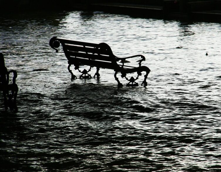
Something truly fascinating is unfolding along Budapest’s legendary riverfront that’s capturing everyone’s attention. The mighty Danube River, normally flowing at predictable summer levels, has transformed into a dramatic natural spectacle with water levels rising at breathtaking speed over the past three weeks.
The numbers tell an incredible story of nature’s power. As of Tuesday morning, the water level reached 353 centimeters at Budapest’s central measuring station, representing a staggering two-meter increase in just a matter of days. This lightning-fast transformation stems from significant rainfall across the Danube’s vast watershed, with massive amounts of water cascading down from Austria and Slovakia, creating an impressive flood wave heading toward the Hungarian capital.
For international visitors, this presents a rare opportunity to witness one of Europe’s most important rivers in full dramatic display. The Hungarian Hydroinfo service predicts the flood wave will continue until Friday morning, with water levels expected to peak at approximately 427 centimeters on August 1st. This creates an almost theatrical atmosphere along the riverfront, where the normally calm Danube demonstrates the raw power that has shaped Central European civilization for millennia.
Safety First: Why Visitors Can Enjoy the Show Without Worry
While the dramatic water level changes might seem alarming to tourists unfamiliar with Budapest’s sophisticated flood management systems, there’s absolutely no cause for concern. The Hungarian authorities have developed comprehensive safety protocols refined over decades of experience managing the Danube’s seasonal variations.
The current water level of around 4 meters, while classified as the lower boundary of flood conditions, remains well within safe parameters. Budapest’s critical flood zone doesn’t begin until water reaches 620 centimeters – nearly two full meters higher than current predictions. This substantial safety buffer demonstrates the robust engineering and careful planning that protects this beautiful capital city.
The authorities might temporarily close lower embankments to vehicle traffic as a precautionary measure, but this actually enhances the experience for pedestrians and tourists. These closures create unique car-free zones along some of Budapest’s most scenic riverfront stretches, offering visitors unprecedented access to viewpoints that are normally bustling with traffic.
Historical context adds perspective to the current situation. Last September, the Danube reached a record-breaking 830 centimeters, forcing significant event cancellations and restrictions throughout the city. That dramatic example illustrates just how much safety margin exists with current water levels, allowing visitors to enjoy the spectacle without any safety concerns.
Advanced Flood Protection: Engineering Meets Heritage
Budapest’s flood protection system represents a masterful blend of cutting-edge engineering and respect for historical heritage. The city has learned from centuries of Danube floods, developing sophisticated defenses that protect residents and infrastructure while preserving the riverside character that makes Budapest so enchanting.
The Római-part area in northern Budapest showcases this balanced approach perfectly. This historically flood-prone district is receiving state-of-the-art flood barriers scheduled for completion by 2029, designed to protect approximately 50,000 residents while maintaining the recreational atmosphere that attracts both locals and tourists. These modern defenses demonstrate how 21st-century cities can achieve safety without sacrificing beauty or accessibility.
Best deals of Budapest


Water management specialists emphasize that current flood protection goes far beyond traditional barriers. The system incorporates sophisticated monitoring technology, predictive modeling, and coordinated response protocols that allow authorities to manage flood events with precision. This comprehensive approach means that even during significant flood events, essential city functions continue operating, and tourist activities remain largely unaffected.
The integration of flood protection with urban development planning ensures that new infrastructure projects enhance rather than compromise the city’s resilience. Every bridge design, every riverside development, and every public space improvement considers flood scenarios, creating a city that’s both more beautiful and more secure for future generations.
Perfect Viewing Opportunities for Curious Visitors
The current flood situation creates exceptional opportunities for tourists to experience Budapest from unique perspectives. The temporarily elevated water levels transform familiar riverside scenes into something extraordinary, offering dramatic photo opportunities and insights into the natural forces that have shaped this remarkable city.
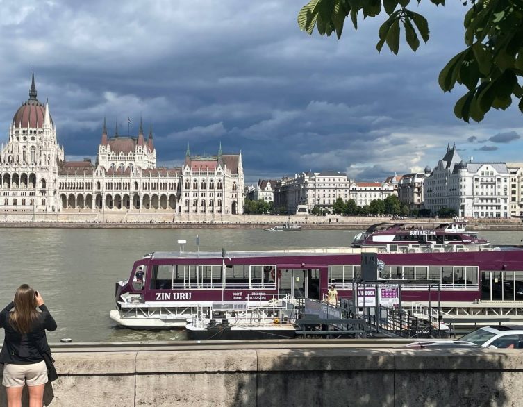
Elevated viewpoints like Buda Castle, Gellért Hill, and the Fisherman’s Bastion provide spectacular vantage points for observing the swollen Danube safely. From these locations, visitors can appreciate the full scope of the flood wave while enjoying Budapest’s most iconic panoramic views. The contrast between the turbulent river and the serene historic architecture creates particularly striking visual compositions.
The temporary closure of lower embankments to vehicle traffic actually improves the tourist experience in many areas. Popular riverside promenades become peaceful pedestrian zones where visitors can observe the flood waters up close while learning about Budapest’s relationship with its great river. Local guides often use these moments to share fascinating stories about historical floods and the engineering marvels that protect the modern city.
Nature’s Reminder of Urban Resilience
What makes Budapest’s current flood situation particularly compelling for international visitors is how it demonstrates the dynamic relationship between nature and urban civilization. The rising Danube serves as a powerful reminder that even the most sophisticated cities must respect and adapt to natural forces that have shaped European landscapes for thousands of years.
The flood wave currently flowing toward Budapest carries water from across Central Europe, connecting the Hungarian capital to distant mountains, forests, and cities through the continent’s second-longest river system. This geographic perspective helps visitors understand Budapest’s position not just as a beautiful tourist destination, but as a crucial node in the great natural and cultural networks that define Central Europe.
Modern flood management transforms what could be a crisis into a manageable natural event that adds character and drama to the urban experience. The sophisticated monitoring systems, protective infrastructure, and coordinated response capabilities ensure that the Danube’s seasonal variations enhance rather than threaten the city’s appeal to international visitors.
The current situation perfectly illustrates how Budapest balances respect for natural forces with determination to maintain its role as one of Europe’s most vibrant and accessible capitals. For tourists, this creates an opportunity to witness both the timeless power of the Danube and the impressive capabilities of modern urban engineering working in harmony to protect and preserve one of the continent’s most beautiful cities.
Related news